Showing 40 items matching campaspe river
-
 Eltham District Historical Society Inc
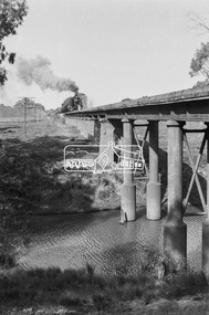
Photograph, Steam locomotive K-158 crossing the railway bridge over the Campaspe River at Rochester, Victoria, c.November 1963, 1963
... Campaspe River at Rochester, Victoria, c.November 1963... newport workshops), railway bridge, Campaspe River, Rochester...It is the railway bridge over the Campaspe River... bridge over the Campaspe River at Rochester, Victoria, c.November ...It is the railway bridge over the Campaspe River at Rochester, Vic. original to the construction of the line. It was taken late on a Saturday morning and shows the regular goods train of that period approaching, then crossing the bridge. I originally planned to take just one view. The approaching train was first then it was a rapid run back along the raised river bank to get the broadside shot. I had little time to steady myself or properly check camera settings, hence the slightly soft focus etc. The train would eventually continue over the Echuca Iron Bridge into NSW. I think its ultimate destination was Deniliquin but not sure.Digital TIFF file Scan of 35mm Ilford FP3 black and white negative transparencygeorge coop collection, k-158, k-class steam locomotive (vr newport workshops), railway bridge, campaspe river, rochester -
 Eltham District Historical Society Inc
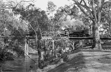
Photograph, Steam locomotive K-158 crossing the railway bridge over the Campaspe River at Rochester, Victoria, c.November 1963, 1963
... Campaspe River at Rochester, Victoria, c.November 1963... newport workshops), railway bridge, Campaspe River, Rochester...It is the railway bridge over the Campaspe River... bridge over the Campaspe River at Rochester, Victoria, c.November ...It is the railway bridge over the Campaspe River at Rochester, Vic. original to the construction of the line. It was taken late on a Saturday morning and shows the regular goods train of that period approaching, then crossing the bridge. I originally planned to take just one view. The approaching train was first then it was a rapid run back along the raised river bank to get the broadside shot. I had little time to steady myself or properly check camera settings, hence the slightly soft focus etc. The train would eventually continue over the Echuca Iron Bridge into NSW. I think its ultimate destination was Deniliquin but not sure.Digital TIFF file Scan of 35mm Ilford FP3 black and white negative transparencygeorge coop collection, k-158, k-class steam locomotive (vr newport workshops), railway bridge, campaspe river, rochester -
 Port of Echuca
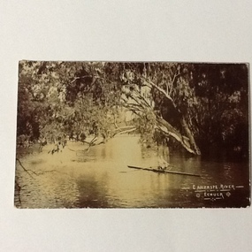
A black and white photographic postcard, Between 08/1906 - 10/1906
... Campaspe River, Echuca... century and this shows the Campaspe river, Echuca in flood...Black and white photographic postcard showing the Campaspe...On face : "Campaspe River, Echuca". On reverse: printed... photographic postcard showing the Campaspe river, Echuca, in flood ...Photographic Postcards were very popular in the early 20th century and this shows the Campaspe river, Echuca in flood. The high water mark is exemplified by having the rower on the water. The water has inundated the surrounding bush with trees partly submerged along the right hand side of the photograph.Rowing clubs were popular in towns along the Murray river and this picturesque scene of the Campaspe river , Echuca in flood shows a man rowing a racing scull down the river.Black and white photographic postcard showing the Campaspe river, Echuca, in flood, with a man rowing a racing scull.On face : "Campaspe River, Echuca". On reverse: printed in ink :" Post Card. This space may be used for correspondence. For address only. Place penny stamp here." In pencil is written: "Aug Sep Oct 1906 Flood" "Donation H V Evans 85 Fullers Rd Chatswood NSW." " Echuca Regional Library" is stamped but has been crossed out in pen.campaspe river, echuca, echuca flood, 1906, rowing, echuca -
![Scene on the River Campaspe / [by] Nicholas Caire, circa 1876](https://victoriancollections.net.au/media/collectors/550653872162f11fb04854aa/items/577b50b0d0cdd10948cb4cf6/item-media/577b51d2d0cdd10948cbedda/item-fit-380x285.jpg) Kew Historical Society Inc
Kew Historical Society IncPhotograph, Anglo-Australasian Photographic Company, Scene on the River Campaspe, c. 1876
... Scene on the River Campaspe... on the River Campaspe’ / Albumen silver photograph mounted on board...On Reverse: ‘The River Campaspe flows into the River Murray... Photograph Photograph Scene on the River Campaspe Views of Victoria ...Nicholas Caire was born on Guernsey in the Channel Islands in 1837. He arrived in Adelaide with his parents in about 1860. In 1867, following photographic journeys in Gippsland, he opened a studio in Adelaide. From 1870 to 1876 he lived and worked in Talbot in Central Victoria. In 1876 he purchased T. F. Chuck's studios in the Royal Arcade Melbourne. In 1885, following the introduction of dry plate photography, he began a series of landscape series, which were commercially successful. As a photographer, he travelled extensively through Victoria, photographing places few of his contemporaries had previously seen. He died in 1918. Reference: Jack Cato, 'Caire, Nicholas John (1837–1918)', Australian Dictionary of Biography.An original, rare photograph from the series 'Views of Victoria: General Series' by the photographer, Nicholas Caire (1837-1918). The series of 60 photographs that comprise the series was issued c. 1876 and reinforced a neo-Romantic view of the Australian landscape to which a growing nationalist movement would respond. Nicholas Caire was active as a photographer in Australia from 1858 until his death in 1918. His vision of the Australian bush and pioneer life had a counterpart in the works of Henry Lawson and other nationalist poets, authors and painters.Views of Victoria (General Series) No.25 / ‘Scene on the River Campaspe’ / Albumen silver photograph mounted on boardOn Reverse: ‘The River Campaspe flows into the River Murray, near the Town of Echuca. It is a river of considerable size, and is subject to frequent overflowing of its banks, in consequence of the low flat country through which it runs. Our illustration represents the River during one of the periodical floods, its depth being over thirty feet at the time.’nicholas caire (1837-1918), australia - landscape photography -
 Ballarat Heritage Services
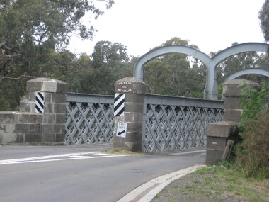
Photograph, Redesdale Bridge, 2016, 18/01/2016
... campaspe river... with bluestone abutments which was installed over the Campaspe River... the Campaspe River in January 1868, although the bridge actually bears ...The Redesdale Bridge is a wrought iron and timber structure with bluestone abutments which was installed over the Campaspe River in January 1868, although the bridge actually bears the date 1867. In 1859, the "Herald of the Morning", a ship carrying a cargo including 350 tons of ironwork for the Hawthorn bridge, caught fire and was scuttled a quarter of a mile off the jetty at Sandridge. A Melbourne salvaging firm raised the ironwork from the bottom of the bay, but after details of an arranged sale to the government caused a scandal in Parliament, the material was sold privately to the Melbourne foundry Langlands & Co. Two hundred tons of it was sold to the goldfields shires of McIvor and Metcalfe for only £1000. The bridge was designed by engineer T.B. Muntz and built by a contractor named Doran, and was completed late and considerably over budget at £6274. The bridge spans 45.7m across the river and has two roadways which are carried between three metal lattice girders in a through truss configuration. The design for the Hawthorn bridge had the deck supported over the trusses, and to stiffen the through truss configuration three sets of distinctive paired arches connect the trusses above the roadways. The roadway decking is constructed of longitudinally placed timbers on timber cross girders which rest on the lower chords of the trusses. (Heritage Victoria) A number of colour photographs showing the historic bridge at Metcalfe.metcalfe, shire of metcalfe, bridge, municipal boundary, shire of mcivor, redesdale bridge, campaspe river, t.b. muntz, doran -
 Federation University Historical Collection
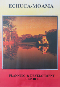
Report, Echuca Moama Tourism Planning and Development Strategy, 1993, 06/1993
... campaspe river... echuca moama hopwood's ferry murray river goulburn river campaspe ...Report compiled by four students of 'Tourism Planning and Development' at Ballarat University College (later Federation University Australia).victorian tourism industry, tourism, alumni, echuca, moama, hopwood's ferry, murray river, goulburn river, campaspe river, gaming, port of echuca -
 Federation University Historical Collection
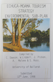
Report, Echuca Moama Tourism Strategy Environmental Sub-Plan, 1993, 12/06/1998
... campaspe river... goulburn river campaspe river gaming port of echuca river red gums ...Report compiled by five students of Tourism at the University of Ballarat (later Federation University Australia).victorian tourism industry, tourism, alumni, echuca, moama, hopwood's ferry, murray river, goulburn river, campaspe river, gaming, port of echuca, river red gums, wetlands, emmy lou, paddle steamer, star hotel, echuca farmyard, echuca coach house -
 Federation University Historical Collection
Report, Echuca Moama Tourism Planning and Development Strategy, c1996
... campaspe river... ferry murray river goulburn river campaspe river gaming Susan ...Report compiled by three students of 'Tourism Planning and Development' at Ballarat University College (later Federation University Australia).victorian tourism industry, tourism, alumni, echuca, moama, hopwood's ferry, murray river, goulburn river, campaspe river, gaming -
 Bendigo Historical Society Inc.
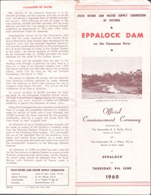
Pamphlet - Aileen and John Ellison collection: Eppalock dam
... . Eppalock Dam on the Campaspe River. Official commencement ceremony... Commission of Victoria. Eppalock Dam on the Campaspe River. Official ...State Rivers and water Supply Commission of Victoria. Eppalock Dam on the Campaspe River. Official commencement ceremony performed by the Honorable H.E. Bolte MLA Premier of Victoria and the Honorable W.J.Mibus MLA minister of water supply at Eppalock on Thursday, 9th June 1960. lake eppalock, eppalock dam -
 Bendigo Historical Society Inc.
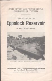
Booklet - Aileen and John Ellison collection: Eppalock Reservoir
... Booklet by the State Rivers and Water Supply Commission... of the Eppalock Reservoir on the Campaspe River. Reprinted from "Aqua ...Booklet by the State Rivers and Water Supply Commission of Victoria - Construction of the Eppalock Reservoir on the Campaspe River. Reprinted from "Aqua", official journal of the State rivers and water supply commission, 1960 (Vol.11, Nos. 9 and 11, May and July, 1960)lake eppalock, reservoir -
 Bendigo Historical Society Inc.
Book - Out and About around Bendigo. Volume 2
... of the Campaspe River down to Runnymede before turning east out... from Bagshot up to Rochester then just east of the Campaspe ...Out and About around Bendigo Volume 2 falls within the area from Bagshot up to Rochester then just east of the Campaspe River down to Runnymede before turning east out to Colbinabbin area then south down to and around Heathcote Redesdale Kyneton and Woodend before returning along the Calder Highway to Ravenswood through Sedgewick Longlea and Fosterville then northwest to Bagshot.500 photographs Mauve outer edge with yellow insert and black writing photos of Bills water troughs Rochester Steam engine Toolleen and valley of liquid ambers Heathcote . Author Jean and Ken Arnold 96 Pages . Back cover Map and photosDymocks Book Shop tagblack and white plaques and photos, buildings -
 City of Greater Bendigo - Civic Collection
Photograph - Portrait of Councillor Patterson, W H Robinson
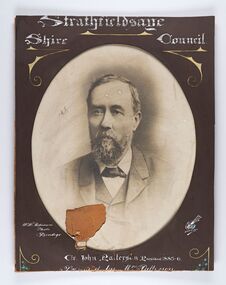
... from the Calder Highway to the Coliban and Campaspe Rivers... Highway to the Coliban and Campaspe Rivers. The shire's ...The district of Strathfieldsaye was proclaimed in 1861 and named a Shire on the 17th September in 1866. It remained a shire until amalgamation in 1994 when it became part of the City of Greater Bendigo. The shire was located 8 km to the south- east of Bendigo and covered an area of 601 square kilometres and extended from the Calder Highway to the Coliban and Campaspe Rivers. The shire's administration centre was in Strathfieldsaye until 1972 when new offices were opened in Kennington. Framed black and white head and shoulder portrait of Councillor Patterson with hand coloured and drawn detail. Profile slightly to left, face is bearded. Cut oval brown mount decorated with text and flowers. Hand written title top and lower centre.Strathfieldsaye / Shire Council / W. H. Robinson / Photo / Bendigo J N B Gribble / Cr John Patterson President 1885 -6 / Presented by Mrs Pattersonstrathfieldsaye shire council, councillor patterson, president of strathfieldsaye shire -
 City of Greater Bendigo - Civic Collection
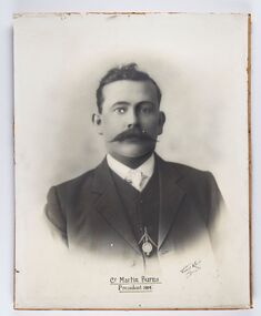
Photograph - Portrait of Councillor Burns, Vincent Kelly
... from the Calder Highway to the Coliban and Campaspe Rivers... and Campaspe Rivers. The shire's administration centre ...The district of Strathfieldsaye was proclaimed in 1861 and named a Shire on the 17th September in 1866. It remained a shire until amalgamation in 1994 when it became part of the City of Greater Bendigo. The shire was located 8 km to the south- east of Bendigo and covered an area of 601 square kilometres and extended from the Calder Highway to the Coliban and Campaspe Rivers. The shire's administration centre was in Strathfieldsaye until 1972 when new offices were opened in Kennington.Framed black and white head and shoulder portrait of Councillor Burns with hand coloured and drawn detail. Front profile with walrus moustache, image encircled. No mount. Hand written title lower centre. Cr Martin Burns / President 1914 / Vincent Kelly / Bendigostrathfieldsaye shire council, councillor burns, president of strathfieldsaye shire -
 City of Greater Bendigo - Civic Collection
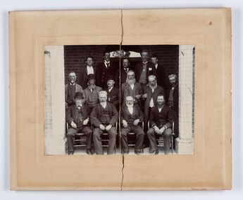
Photograph - Councillor group portrait, D.G. Coope & Son - Framers
... from the Calder Highway to the Coliban and Campaspe Rivers... and Campaspe Rivers. The shire's administration centre ...The district of Strathfieldsaye was proclaimed in 1861 and named a Shire on the 17th September in 1866. It remained a shire until amalgamation in 1994 when it became part of the City of Greater Bendigo. The shire was located 8 km to the south- east of Bendigo and covered an area of 601 square kilometres and extended from the Calder Highway to the Coliban and Campaspe Rivers. The shire's administration centre was in Strathfieldsaye until 1972 when new offices were opened in Kennington.Framed photographic group portrait of fifteen men taken in the alcove of the Strathfieldsaye Shrie Hall. Four men are seated and eleven are standing. Photograph is attached directly to cream mount card. Handwritten note with photograph: 1/. John Burke 2/. 3/. 4/. RHS Abbott 5/. M Brennan 6/. 7/. 1/. M Condon? 2/. 3/. M Burns 4/. Gentlemen at back are council staff not councilors.shire of strathfieldsaye, strathfieldsaye shire council, president of strathfieldsaye shire, councillor john burke, councillor r.h.s. abbott, councillor brennan, councillor condon, councillor m burns -
 City of Greater Bendigo - Civic Collection
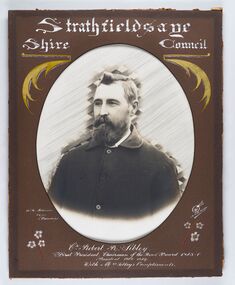
Photograph - Portrait of Councillor Sibley, W H Robinson
... from the Calder Highway to the Coliban and Campaspe Rivers... from the Calder Highway to the Coliban and Campaspe Rivers ...The district of Strathfieldsaye was proclaimed in 1861 and named a Shire on the 17th September in 1866. It remained a shire until amalgamation in 1994 when it became part of the City of Greater Bendigo. The shire was located 8 km to the south- east of Bendigo and covered an area of 601 square kilometres and extended from the Calder Highway to the Coliban and Campaspe Rivers. The shire's administration centre was in Strathfieldsaye until 1972 when new offices were opened in KenningtonFramed black and white head and shoulder portrait of Councillor Sibley with hand coloured and drawn detail. Profile slightly to left with walrus moustache and beard. Cut oval brown mount decorated with text, flowers and scrolls. Hand written title top and lower centre.Strathfieldsaye / Shire Council / W m Robinson / Photo / Bendigo / J N B Gribble / Cr Robert R Sibley / First President Chairman of the Road Board 1865 - 5 / President 1866 - 1869 / With Mrs Sibley's Complimentsstrathfieldsaye shire council, councillor sibley, president of strathfieldsaye shire -
 City of Greater Bendigo - Civic Collection
Photograph - Portrait of Councillor Hargraves, Bartlett Bros
... from the Calder Highway to the Coliban and Campaspe Rivers... and Campaspe Rivers. The shire's administration centre ...The district of Strathfieldsaye was proclaimed in 1861 and named a Shire on the 17th September in 1866. It remained a shire until amalgamation in 1994 when it became part of the City of Greater Bendigo. The shire was located 8 km to the south- east of Bendigo and covered an area of 601 square kilometres and extended from the Calder Highway to the Coliban and Campaspe Rivers. The shire's administration centre was in Strathfieldsaye until 1972 when new offices were opened in KenningtonFramed black and white head and shoulder portrait of Councillor Hargraves. Profile slightly to right with walrus moustache. Cut rectangle brown mount decorated with coloured text and scrolls. Hand written title top and lower centre.Strathfiledsaye Shire Council / Cr John Hargreaves / President 1919 - 20 1928 - 29 / Presented by his Wife & Familystrathfieldsaye shire council, president of strathfieldsaye shire, councillor hargreaves -
 City of Greater Bendigo - Civic Collection
Photograph - Portrait of Councillor Long, Talma & Co
... from the Calder Highway to the Coliban and Campaspe Rivers... to the Coliban and Campaspe Rivers. The shire's administration centre ...The district of Strathfieldsaye was proclaimed in 1861 and named a Shire on the 17th September in 1866. It remained a shire until amalgamation in 1994 when it became part of the City of Greater Bendigo. The shire was located 8 km to the south- east of Bendigo and covered an area of 601 square kilometres and extended from the Calder Highway to the Coliban and Campaspe Rivers. The shire's administration centre was in Strathfieldsaye until 1972 when new offices were opened in Kennington.Framed black and white head and shoulder portrait of Councillor Long. Profile to left with walrus moustache and mutton chops. Cut olive retangle mount. Verso; Long. On under board which has photograph attached; Talma & Co. / 119 Swanston St., / Melbournestrathfieldsaye shire council, councillor long -
 City of Greater Bendigo - Civic Collection
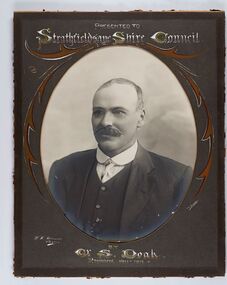
Photograph - Portrait of Councillor Doak, W H Robinson
... from the Calder Highway to the Coliban and Campaspe Rivers... to the Coliban and Campaspe Rivers. The shire's administration centre ...The district of Strathfieldsaye was proclaimed in 1861 and named a Shire on the 17th September in 1866. It remained a shire until amalgamation in 1994 when it became part of the City of Greater Bendigo. The shire was located 8 km to the south- east of Bendigo and covered an area of 601 square kilometres and extended from the Calder Highway to the Coliban and Campaspe Rivers. The shire's administration centre was in Strathfieldsaye until 1972 when new offices were opened in Kennington.Framed black and white head and shoulder portrait of Councillor Doak with hand coloured and drawn detail. Left facing profile with walrus moustache. Cut oval brown mount decorated with text and scrolls. Hand written title top and lower centre.Presented to / Strathfieldsaye Shire Council / W. H. Robinson / Photo / JMB Gribble / by Cr S. Doak / President 1911 - 1912strathfieldsaye shire council, president of strathfieldsaye shire, councillor doak -
 City of Greater Bendigo - Civic Collection
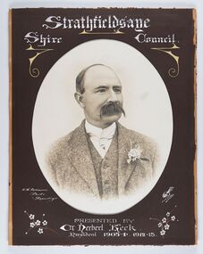
Photograph - Portrait of Councillor Keck, W H Robinson, c 1913
... from the Calder Highway to the Coliban and Campaspe Rivers... Highway to the Coliban and Campaspe Rivers. The shire's ...The district of Strathfieldsaye was proclaimed in 1861 and named a Shire on the 17th September in 1866. It remained a shire until amalgamation in 1994 when it became part of the City of Greater Bendigo. The shire was located 8 km to the south- east of Bendigo and covered an area of 601 square kilometres and extended from the Calder Highway to the Coliban and Campaspe Rivers. The shire's administration centre was in Strathfieldsaye until 1972 when new offices were opened in Kennington.Framed black and white head and shoulder portrait of Councillor Keck with hand coloured and drawn detail. Profile slightly to right with walrus moustache. Cut oval brown mount decorated with text and flowers. Hand written title top and lower centre.Strathfieldsaye / Shire Council / W.H. Robinson / Photo / Bendigo / J.H.E Gribbs / Presented by / Cr Herbert Keck / President 1903-4. 1912-13.shire of strathfieldsaye, councillor keck, strathfieldsaye shire council, president of strathfieldsaye shire -
 City of Greater Bendigo - Civic Collection
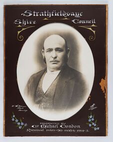
Photograph - Portrait of Councillor Michael Condon, W H Robinson
... from the Calder Highway to the Coliban and Campaspe Rivers... from the Calder Highway to the Coliban and Campaspe Rivers ...The district of Strathfieldsaye was proclaimed in 1861 and named a Shire on the 17th September in 1866. It remained a shire until amalgamation in 1994 when it became part of the City of Greater Bendigo. The shire was located 8 km to the south- east of Bendigo and covered an area of 601 square kilometres and extended from the Calder Highway to the Coliban and Campaspe Rivers. The shire's administration centre was in Strathfieldsaye until 1972 when new offices were opened in KenningtonFramed black and white head and shoulder portrait of Councillor Condon with hand coloured and drawn detail. Profile slightly to left. No facial hair. Cut oval brown mount decorated with text, scrolls and flowers. Hand written title top and lower centre.Strathfieldsaye / Shire / Council / W. H. Robinson / Photo / Bendigo / JMB Gribble / Presented by / Cr Michael Condon / President 1889 - 90. 1895-6. 1904 - 5strathfieldsaye shire council, president of strathfieldsaye shire, councillor condon -
 City of Greater Bendigo - Civic Collection
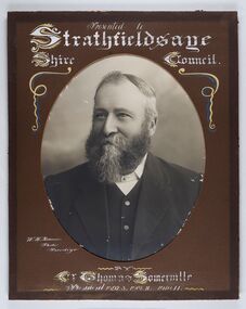
Photograph - Portrait of Councillor Thomas Somerville, W H Robinson
... from the Calder Highway to the Coliban and Campaspe Rivers... Highway to the Coliban and Campaspe Rivers. The shire's ...The district of Strathfieldsaye was proclaimed in 1861 and named a Shire on the 17th September in 1866. It remained a shire until amalgamation in 1994 when it became part of the City of Greater Bendigo. The shire was located 8 km to the south- east of Bendigo and covered an area of 601 square kilometres and extended from the Calder Highway to the Coliban and Campaspe Rivers. The shire's administration centre was in Strathfieldsaye until 1972 when new offices were opened in KenningtonFramed black and white head and shoulder portrait of Councillor Somerville with hand drawn detail. Profile slightly to left, face has full beard. Cut oval brown mount decorated with text and scrolls. Hand written title top and lower centre.Presented to / Strathfieldsaye / Shire Council / W. H. Robinson / Photo / Bendigo / by / Cr Thomas Somerville / President 1892 - 3. 1901.2. 1910.11 strathfieldsaye shire council, councillor somerville, president of strathfieldsaye shire -
 City of Greater Bendigo - Civic Collection
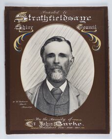
Photograph - Portrait of Councillor Burke
... from the Calder Highway to the Coliban and Campaspe Rivers... and Campaspe Rivers. The shire's administration centre ...The district of Strathfieldsaye was proclaimed in 1861 and named a Shire on the 17th September in 1866. It remained a shire until amalgamation in 1994 when it became part of the City of Greater Bendigo. The shire was located 8 km to the south- east of Bendigo and covered an area of 601 square kilometres and extended from the Calder Highway to the Coliban and Campaspe Rivers. The shire's administration centre was in Strathfieldsaye until 1972 when new offices were opened in Kennington. Framed black and white head and shoulder portrait of Councillor Burke with hand coloured and drawn detail. Profile centre facing with beard. Cut oval brown mount decorated with text and fscrolls. Hand written title top and lower centre. Wooden frame with detail and gold inner.Presented to Strathfieldsaye / shire Council / w. H. robinson / Photo / Bendigo / By the family of / Cr John Burke / President 1890 - 1899 - 1900strathfieldsaye shire council, councillor burke, president of strathfieldsaye shire -
 City of Greater Bendigo - Civic Collection
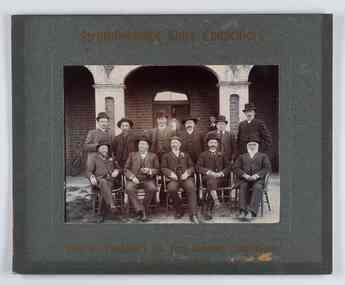
Photograph - Councillor group portrait, W H Robinson, Strathfieldsaye Shire Council, 1909
... from the Calder Highway to the Coliban and Campaspe Rivers... to the Coliban and Campaspe Rivers. The shire's administration centre ...The district of Strathfieldsaye was proclaimed in 1861 and named a Shire on the 17th September in 1866. It remained a shire until amalgamation in 1994 when it became part of the City of Greater Bendigo. The shire was located 8 km to the south- east of Bendigo and covered an area of 601 square kilometres and extended from the Calder Highway to the Coliban and Campaspe Rivers. The shire's administration centre was in Strathfieldsaye until 1972 when new offices were opened in Kennington.Photographic group portrait of eleven Strathfieldsaye Shire Councillors in front of the Strathfieldsaye Shire Hall. Five men are seated and six standing with one man standing further in back ground on the building's verandah. Photograph is attached directly to green mount card and framed. Gold lettering on mount.Strathfieldsaye Shire Councillors / R. B. Brennan (Sec.) W. J. Lowdes S. Doak M. Burns () N Condon B. Code (Inspector) / WH Robinson Photo Bendigo / T Somerville / W. I. Long / Fred Osborne (President) H Keck / W Dresler / With the President's (Cr. Fred Osborne) Compliments / September 23rd, 1909shire of strathfieldsaye, strathfieldsaye shire council, president of strathfieldsaye shire, strathfieldsaye shire hall -
 City of Greater Bendigo - Civic Collection
Photograph - Councillor group portrait, W H Robinson, Strathfieldsaye Shire Council
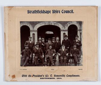
... from the Calder Highway to the Coliban and Campaspe Rivers... to the Coliban and Campaspe Rivers. The shire's administration centre ...The district of Strathfieldsaye was proclaimed in 1861 and named a Shire on the 17th September in 1866. It remained a shire until amalgamation in 1994 when it became part of the City of Greater Bendigo. The shire was located 8 km to the south- east of Bendigo and covered an area of 601 square kilometres and extended from the Calder Highway to the Coliban and Campaspe Rivers. The shire's administration centre was in Strathfieldsaye until 1972 when new offices were opened in Kennington. Group portrait of 13 men / councilors, 5 seated and 8 standing dressed in suits. There are another 2 men further back in front of the hall doors. Photograph is taken outside the Strathfieldsaye Shire Hall.Srathfieldsaye Shire Council. / With the President's (Cr T. Somerville) Compliments. / September, 1910 / W.H. Robinson Photo. Bendigo Verso; William Drechslershire of strathfieldsaye, president of strathfieldsaye shire, strathfieldsaye shire council -
 City of Greater Bendigo - Civic Collection
Sign - Shire of Strathfieldsaye Coat of Arms
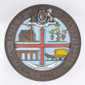
... from the Calder Highway to the Coliban and Campaspe Rivers... Highway to the Coliban and Campaspe Rivers. The shire's ...The district of Strathfieldsaye was proclaimed in 1861 and named a Shire on the 17th September in 1866. It remained a shire until amalgamation in 1994 when it became part of the City of Greater Bendigo. The shire was located 8 km to the south- east of Bendigo and covered an area of 601 square kilometres and extended from the Calder Highway to the Coliban and Campaspe Rivers. The shire's administration centre was in Strathfieldsaye until 1972 when new offices were opened in Kennington. This coat of arms was commissioned for the front of the shire hall building.Brass painted coat of arms or emblem within a circle of the Shire of Strathfieldsaye. Outer rim contains text: SHIRE OF STRATHFIELDSAYE VICTORIA 1866 with the shield of the monarch of the United Kingdom centre top. The shield is divided into four parts with images reflecting the leading industries of the time; wine growing, mining, farming and tanning. The motto PROGRESS is depicted lower centre of shield. SHIRE OF STRATHFIELDSAYE / VICTORIA / 1866 / PROGRESSshire of strathfieldsaye, city of greater bendigo amalgamation, city of greater bendigo signs -
 City of Greater Bendigo - Civic Collection
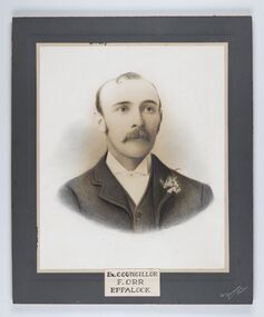
Photograph - Portrait of Councillor Orr, The Yeoman Studios, Ex. Councillor / F. Orr / Eppalock
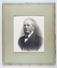
... from the Calder Highway to the Coliban and Campaspe Rivers... and Campaspe Rivers. The shire's administration centre ...The district of Strathfieldsaye was proclaimed in 1861 and named a Shire on the 17th September in 1866. It remained a shire until amalgamation in 1994 when it became part of the City of Greater Bendigo. The shire was located 8 km to the south- east of Bendigo and covered an area of 601 square kilometres and extended from the Calder Highway to the Coliban and Campaspe Rivers. The shire's administration centre was in Strathfieldsaye until 1972 when new offices were opened in Kennington. Eppalock Ward is one of three wards in the Greater Bendigo municipality which includes the former Strathfieldsaye Shire. Framed black and white head and shoulder portrait with hand coloured detail. Man with profile slightly to right, walrus moustache, image encircled. Photograph is attached to mount card. Hand written title lower centre.Ex. Councillor / F. Orr / Eppalock / The / Yeoman / Studiosshire of strathfieldsaye, councillor orr -
 City of Greater Bendigo - Civic Collection
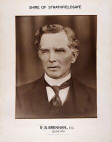
Photograph - Portrait of Shire Secretary Brennan, Unknown
... from the Calder Highway to the Coliban and Campaspe Rivers... from the Calder Highway to the Coliban and Campaspe Rivers ...The district of Strathfieldsaye was proclaimed in 1861 and named a Shire on the 17th September in 1866. It remained a shire until amalgamation in 1994 when it became part of the City of Greater Bendigo. The Shire was located 8 km to the south- east of Bendigo and covered an area of 601 square kilometres and extended from the Calder Highway to the Coliban and Campaspe Rivers. The shire's administration centre was in Strathfieldsaye until 1972 when new offices were opened in Kennington. Secretary Brennan, son of Councillor M. Brennan was appointed after his fathers death to the role and according to the The Bendigo Independent was in the role in 1917. See References.Framed black and white head and shoulder portrait of Councillor Brennan. Profile slightly to left. Cut rectangle cream mount. Hand written title top and lower centre. Shire of Strathfieldsaye / R. B. Brennan, Esq / Secretarystrathfieldsaye shire council, secretary strathfieldsaye shire -
 City of Greater Bendigo - Civic Collection
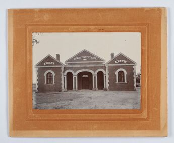
Photograph - Strathfieldsaye Shire Hall
... from the Calder Highway to the Coliban and Campaspe Rivers... and Campaspe Rivers. The shire's administration activities were centred ...The district of Strathfieldsaye was proclaimed in 1861 and named a Shire on the 17th September in 1866. It remained a shire until amalgamation in 1994 when it became part of the City of Greater Bendigo. The shire was located 8 km to the south- east of Bendigo and covered an area of 601 square kilometres and extended from the Calder Highway to the Coliban and Campaspe Rivers. The shire's administration activities were centred at the Strathfieldsaye Shire Hall which was built in 1869 at a cost of £700 based on a design by George Steane, the shire surveyor and built by George Pallett of Sandhurst. Constructed of red brick, the hall has a unique ventilation system with hollow walls open at the top and bottom to ensure a draught to cool the building in summer. Framed and mounted photograph of the Strathfieldsaye Shire Hall. Verso; W M Robinson / Photographer / Mundy Street Bendigostrathfieldsaye shire hall, shire of strathfieldsaye, strathfieldsaye shire council -
 City of Greater Bendigo - Civic Collection
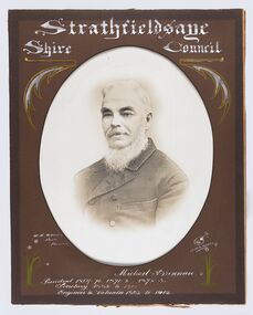
Photograph - Portrait of Councillor Brennan, W H Robinson
... from the Calder Highway to the Coliban and Campaspe Rivers... and Campaspe Rivers. The shire's administration centre ...The district of Strathfieldsaye was proclaimed in 1861 and named a Shire on the 17th September in 1866. It remained a shire until amalgamation in 1994 when it became part of the City of Greater Bendigo. The shire was located 8 km to the south- east of Bendigo and covered an area of 601 square kilometres and extended from the Calder Highway to the Coliban and Campaspe Rivers. The shire's administration centre was in Strathfieldsaye until 1972 when new offices were opened in Kennington. Councillor Michael Brennan held roles of Shire Secretary and Clark of Works until around 1998 when his son R. B. Brennan was appointed Assistant Secretary and then Shire Secretary to assist his father with the work load during his later years. Michael Brennan remained Clerk of Works until his death at which time his son was appointed to the duties previously held by his father. Framed black and white head and shoulder portrait of Councillor Brennan with hand coloured and drawn detail. Profile to left. Cut oval brown mount decorated with text and flowers. Hand written title top and lower centreStrathfieldsaye / Shire Council / W H Robinson / Photo / Bendigo / J H B Gribble / Michael Brennan / President 1869 - 70. 1871 - 2. 1872 - 3 / Secretary 1882 to 1900 / Engineer & Valuator 1882 to 1902strathfieldsaye shire council, councillor brennan, president of strathfieldsaye shire -
 Bendigo Historical Society Inc.
Slide - Dunn's Rock Eppalock, 2012
... the along the Campaspe River. Ongoing weathering, wind and water... buried the original bedrock along the along the Campaspe River ...The low rolling hills of the Kimbolton countryside consist of ancient, hard and fractured Ordovician rock up to 65 million years old, which was originally deposited deep under the sea. Rocks mainly are sandstone, mudstone, black shale and quartz conglomerates. Marine fossils can be found in the area. Around seven million years ago a basalt flow buried the original bedrock along the along the Campaspe River. Ongoing weathering, wind and water movement over the following years has produced younger clay, sand, silt and gravel deposits throughout the area. Patches of White Hills Gravel are also found in the area. Another unique geological feature of this area is the Permian Glacial Pavement rocks north and south of Eppalock and glacial sediments (such as “Dunn’s Rock” and “Kellams Rock”). During the ice age (up to 280 million years ago) large glaciers moving over the countryside, scoured out sediments, pulverized bedrock, polished and cut grooves into bedrock in the direction of ice movement. When the ice melted boulders etc where left behind in areas of entirely different rock types, such as a 100 Tonne granite block known as ‘The Stranger’ near Derrinal. Dunn's Rock (Glaciated Pavement) Eppalock - Photos of the rock and a field group collecting date with Lake Eppalock (Knowsley) in the backgroundhistory, bendigo, dunn's rock eppalock, kimbolton forest, lake eppalock, gately collection